Hunter Valley Settlers
Introduction
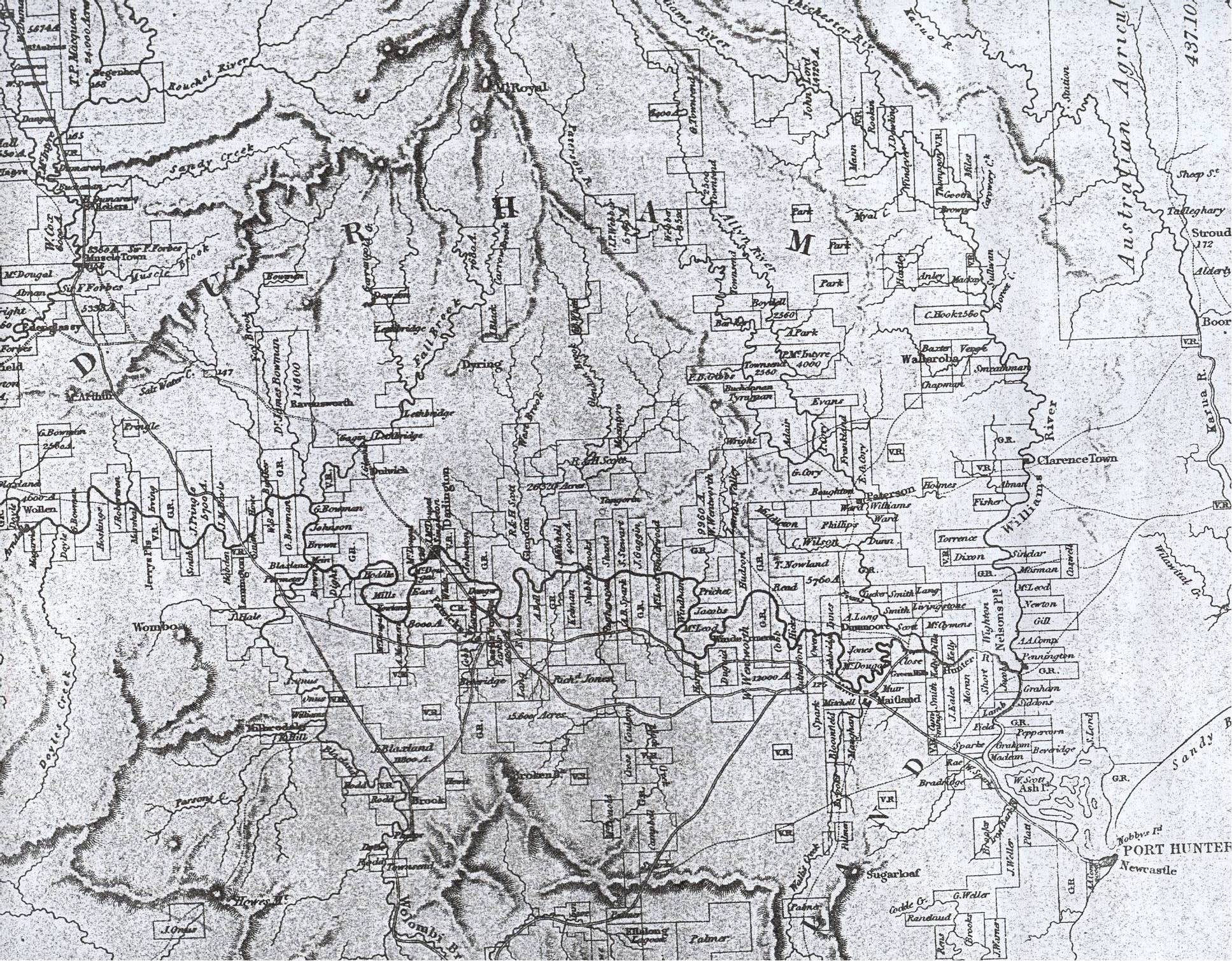 Hunter Valley Map. Click to Enlarge
Read the Introduction below or Select Hunter Valley Settlers Index
The Hunter Valley was the largest of the lowland plains on the New South Wales coast. It was the first area outside the Cumberland Plains to be permanently occupied by white settlers, however these first settlers were small farmers, allowed the indulgence by Governor Macquarie. After the Governor's first visit to Newcastle in January 1812, well behaved convicts John Reynolds, Benjamin Davis, George Pell and Richard Binder and son of convict storekeeper John Tucker (John junior) were permitted to take up land on Patterson's Plains.
In 1817 and 1818 more settlers were allowed farms as well, including John Tucker senior who had retired from his government position at Newcastle; John Powell, John Swan, William Evans, Robert Whitmore, Thomas Addison, Anthony Dwyer and John Reeves. The conditions under which the farms were held were mentioned in an order published in March 1818 warning the farmers that: they were not to regard the land so given them their own property, the right being exclusively vested in the Governor and that they were only allowed to cultivate and to reside on their Farms so granted during their good conduct and the pleasure of His Excellency the Governor.
Governor Macquarie described the country in his Journal on 30th July 1818 :-
Thursday 30th. July. Got up at Day-break and Breakfasted immediately so as to prosecute our Journey up the River. At 10 a.m. we arrived in the Gig at Point Reception, and at the confluence of the 2d. and 3d. Branches of the River. -- We proceeded up this Branch to the Farms some time since permitted by me to be occupied by 6 well behaved Convicts and two Free men. Arrived at the first Farm (young Tucker's) at 1/2 past 11 o'clock, distant about 9 miles from Point Reception, where we landed and walked about for some little time examining the improvements and nature of the Soil, which last is most excellent. We then proceeded to view the rest of the Farms on both sides of this beautiful River -- finding the soil of all of them very good -- and much more ground cleared and cultivated than I had any idea of. -- After we had explored most of the Farms, we quitted the Boat entirely and walked across the Country to the 3d. Branch -- leaving orders with the Gig to meet us next day at Reception Point on our way back. -- The Country between the two Rivers thro' which we travelled was principally fine open Forest Land, very fit for grazing but not for cultivation but we also passed through some very close thick Brush Country and indifferent land. '
Soon afterwards more trusted ex - prisoners and free men were allowed to settle near Maitland also - George Mitchell, Molly Morgan, Richard Martin, Patrick Riley, John Allen, John Smith, Thomas Boardman, Patrick Maloney, John Cahill, John Eckford and William Jones. William Eckford and William O'Donnell were also early small settlers.
Because of the Newcastle Penal settlement there was a deliberate refusal to allow any large scale settlement of the Hunter Valley. Other than the indulgences to the small farmers mentioned above, the granting of acreages in the Hunter Valley was delayed until after the penal settlement closed and convicts were transferred to Port Macquarie. Consequently the majority of the valley's settlers were new immigrants whose enterprise, together with the natural resources of the valley produced a rapid development of both agriculture and stock raising.
After Commissioner Bigge recommended closure of Newcastle penal settlement and relinquishment of the land of the Hunter Valley for free settlement these new settlers began pouring into the area. The river banks of the lower Hunter and their surrounds had been denuded of timber in the preceding years and the land was now seen as a resource for wealth and revenue via agriculture. The new settlers included merchants and military men, agriculturalists, doctors and sea captains. They sailed sixty miles up the coast from Sydney in little colonial vessels and disembarked at the stone wharf at Newcastle. They then transferred to smaller vessels to make the voyage up the river.
Many came with wealth and privilege and under the new laws in NSW had great potential to extend this wealth. They were granted land according to their resources and allocated a convict for every 100 acres able to be effectively developed. Some were also allocated allotments in the township of Newcastle. Many of these early settlers were still on their land when Robert Dixon surveyed the district in 1832. Dixon returned to England in 1836 and while there published a map dated 1837.
Sources used to create Settler Pages
Map 1
William Bradridge
George Brooks
William Brooks
John Eales
John Field
George T Graham
Vicars Jacob
William MacLean
Francis Moran
William Peppercorn
John Laurio Platt
Henry Rae
James St. John. Ranclaud
Alexander W. Scott
Francis Shortt
Richard Siddons
Edward Sparke
William Sparke
Jonathon Warner
Joseph Weller
George Weller
Richard Windeyer
Map 2
James Adair
Samuel Adair
George Adair
Edward Cory
Gilbert Cory
John Cory
William Cummings
Andrew Dixon
Robert Corum Dillon
Leslie Duguid
William Dun
William Evans
George J. Frankland
Standish Lawrence Harris
William Hicks
Beresford Hudson
Richard Jones
James Kelly
James Thomas Lamb
Andrew Lang
Robert Lethbridge
Alexander Livingstone
James McGillivray
George Muir
Thomas McDougall
James McClymont
Timothy Nowlan
Henry Dixon Owen
James Phillips
Richard Charles Pritchett
James Reid
George Shaw Rutherford
Walter Scott
Gentleman John Smith
John Galt Smith
Hugh Torrence
John Tucker
Susannah Matilda Ward
William Charles Wentworth
John Wighton
George Williams
Caleb and Felix Wilson
Thomas W. M. Winder
Map 3
Ferdinand Anley
Alexander MacDuff Baxter
Charles Boydell
Crawford Logan Brown
Matthew Chapman
James Dowling
Francis Gibbes
Duncan Forbes Mackay
Henry Gooch
Grayson Hartley
John Hooke
Henry John Lindeman
John Lord
John McIntyre
John Mann
Lawrence Myles
Alexander Park
Joseph Rookin
Major Smeathman
Benjamin Sullivan
George Townshend
John Verge
Charles Windeyer
Map 4
Archibald Bell junior
James Black
William Brooks
James Busby
John Cobb
Henry Dangar
John Earl
John Gaggin
William Harper
William Kelman
John Larnach
David Maziere
James Mitchell
James Mudie
Robert and Helenus Scott
Alexander Shand
Benjamin Singleton
Alexander Brodie Sparke
Thomas Steele
William M. Shaw Stewart
Joseph Underwood
George Wyndham
George Boyle White
Map 5
William Simms Bell
George Bowman
James Bowman
David Brown
John Martin Davis
Robert Dawson
George Dight;
John Gaggin
James Glennie
James Hale
Rev. Richard Hill
Richard Hobden
Robert Hoddle
John Howe
Sampson Marshall
James Mein
George Galway Mills
Archibald Mosman
Joseph Onus
Thomas Parmeter
Robert Pringle
Robert Adamson Rodd
Map 6
Alexander Anderson
James Arndell
Thomas Arndell
James B Bettington
John H. Bettington
George Blaxland
Charles Cameron
Peter Cunningham
Cyrus MatthewDoyle
John Hoskings
Rev. John McGarvie
William Ogilvie
James Robertson
Map 7
Francis Allman
Joseph H. Bettington
William Buchanan
William Carter
William Cox
Henry Dumaresq
Francis Forbes
George Forbes
Donald McIntyre
Captain John Pike
Samuel Wright
Map 8
Hugh Cameron
William Dangar
William Dumaresq
Thomas Potter Macqueen
Peter McIntyre
Map 9
John Bingle
William Bell Carlyle
Stephen Coxen
Joseph Docker
John Dow
George Hall
Archibald Little
Francis Little
Hamilton C. Sempill
James White
Map 10
Joseph Pennington
Thomas Gill
Jacob Newton
George Mossman
Duncan Sinclair
William Caswell
Francis Allman
William Fisher
Hugh Torrence
Andrew Dixon
John Wighton
Thomas Bartie
Joseph Thew
Sources
1. Australian Medical Pioneers Index
2. Backhouse, James., A Narrative of a visit to the Australian Colonies in 1843
3. Bateson, Charles, The Convict Ships 1787 - 1868, Library of Australian History, 1983
4. Boyle, H.F., Lieutenant Commander Frederick Bedwell R.N, Paterson Historical Society
5. Census of New South Wales. 1828
6. Clouten, Keith, Reid's Mistake; the story of Lake Macquarie from its discovery until 1890. Boolaroo NSW; Lake Macquarie Shire Council
7. Convict Indents
8. Decisions of the Superior Courts of New South Wales 1788 - 1899
9. Early Days of Port Stephens - Extracts from Sir Edward Parry's Diary. Dungog Chronicle
10. Hainsworth, D.R. The Sydney Traders, Simeon Lord and his Contemporaries, Cassell Australian, Melbourne, 1872.
11. Hunter, Cynthia., The Settlers of Paterson's Plains, Paterson Historical Society, 1997
12. Hunter Valley Gazette
13. Index to the Colonial Secretary's Papers, 1788 - 1825
14. Maitland Mercury
15. Mitchell, C., Hunter's River, Estate of Cecily Joan Mitchell, 1984
16. Newcastle Coal Report: History of Newcastle Mines under Crown and Australian Agricultural Company
17. New South Wales Registry of Births Deaths and Marriages
18. Proceedings of the Old Bailey
19. Sydney Gazette
20. Sydney Morning Herald
21. The narrative of a voyage of discovery performed in his majesty's vessel the Lady Nelson of sixty tons burthen, with sliding keels; in the years 1800, 1801, and 1802, to New South Wales
22. Turner, J.W., Manufacturing in Newcastle, 1801 - 1900. Newcastle History Monographs No 8., Newcastle Public Library 1980
23. Uebel , L., The Port Jackson Convicts Anthology, 2001
24. 1832 Directory
25. General Return of Convicts to New South Wales 1837
26. Roope, C., Gregson, P., 'An Organised Banditti,The Story behind the Jewboy Bushranger Gang.,Lake Macquarie, 2002
27. Sydney Herald,December 10th 1840.
28. 1832 Directory
29. Sydney Gazette12 May 1835
30. Sydney Gazette 4 October1834
31. AO 1046 6/6007 CSOL 1832 -1833, 32/972 32. Commercial Journal 4 September 1839
33. Maitland Mercury 24 May 1845
34. Sydney Gazette 4 June 1831
35. Sydney Gazette 9 April 1835
36. Maitland Mercury 17 October 1849
37. Maitland Mercury 10 November 1849
38. Wood, Allan, Dawn in the Valley, Wentworth Books, Sydney, 1972. p131.
39. Turner, J.W. Newcastle as a Convict Settlement: The Evidence before J.T. Bigge in 1819 - 1821, p.128
40. Index and directory to map of the country bordering upon the River Hunter. (1828 Dangar Index)
41.Dangar's Map of the River Hunter (1828)
42. Campbell JF (1926). The Genesis of Rural Settlement on the Hunter. Royal Australian Historical Society, Journal and Proceedings Vol XII part II 1926.
↑