Lawrence Myles - Settler
Map 3
Lawrence Myles arrived in the colony as a free settler on the vessel Adams, Captain Franklin, on 11 November 1828. Other cabin passengers arriving on the Adams included Rv. Joseph Docker and his wife Jane nee Betham; Jane Workman, niece to Mrs. Docker; John E. Turner, settler; William Docker, settler; William Rogers, settler.
Lawrence Myles married Harriet H. Pearson at Campbelltown in 1835.
Land Grant
He was granted 2560 acres of land......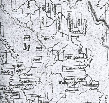
Gloucester - Lawrence Myles, 2560 acres, Upper William River; promised by Sir Ralph Darling on 6th December 1828 to Lawrence Myles as a primary grant, and possession authorised on 28th October 1835 in lieu of the like quantity of which he received possession on 5th March 1829; quit rent 21 5s 8d. per annum, commencing 1st January 1837 [1].
Cobawn Paddy
Settlers in the Upper Williams River district had more than difficult absconding convicts to deal with as Correspondence sent by Lawrence Myles, J.P. Police Office, Dungog to Lieut. Beckhear, commanding the Mounted Police at Jerrys Plains on 20th May 1836 reveals.....Sir, Having this day received intelligence that the blacks are becoming very troublesome at the out stations on the Gloucester River, where the murders were committed last year, and that a large number are collected, headed by Cabean Paddy (Cobawn Paddy), the ringleader of the perpetrators of the late murders, and that they are assembled with similar intentions, I have the honor to request that you will be pleased to direct a party of the Mounted Police under your command to proceed there, calling at Mr. Lords farm, where Mr. Flett will accompany the party.
Description in 1842
The road to Lawrence Myles' farm was described in Teggs Pocket Almanac in 1842...Cross the Williams River to Canningalla, Sir James Dowling's Farm. About a mile on the right is the confluence of the William and Chichester Rivers. Lower down the William on the north bank are the farms of Mr. W. Foster and Lawrence Myles.
From Tillegra there is a track to the south west following upwards the course of the Myall to the right of Mount Narroull and crossing the range by Mount Windeyer to Park's grant on the Allyn River.
Land Sub-Divided
In 1856 the Estate was sub-divided and sold in 28 agricultural farms, all with frontage to the Williams River. They were described as being so near to Dungog and being within a convenient distance of Clarence Town, where the steamers regularly trade to, there is every facility offered to the farmer to send his produce to Sydney or sell it at his own door where there is a market. On many of these farms there are considerable improvements, most have a house and barn built on them.Death
Lawrence Myles died at Cumberland Place, Sydney after a protracted illness on 14 January 1858. He was 62 years of age. His widow lived until 1903. She died at Homebush age 89 years.Notes and Links
Extract from an article of reminiscences of R.W. Alison from the Dungog Chronicle on 1 June 1945......On the bank of the river opposite Dungog was the grant of 2560 acres to Lawrence Myles. It comprised all the river frontage from and including Lowrey's on the south to the property of O.E. Carter on the north. Myles never lived there nor did he do anything to improve it, but sold it to John Hooke for £2000. Hooke paid one thousand and as times got bad he could not pay the balance. He had occupied it for years and he did a great deal of improvements, which he lost when Myles re-possessed the property and after the discovery of gold he subdivided it and sold it by auction somewhere about 1860. The prices realised were as high as £18 per acre.
References
[1]. Sydney Morning Herald 26 May 1846↑